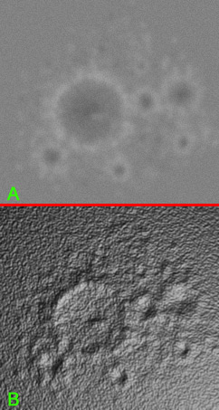
Thethys 4k , download the 1k & 4k versions for testing
-
Topic authort00fri
- Developer
- Posts: 8772
- Joined: 29.03.2002
- Age: 22
- With us: 22 years 7 months
- Location: Hamburg, Germany
Thethys 4k , download the 1k & 4k versions for testing
Hi,
given that the Cyclops imaging team has released hires
maps of various Saturnian moons in December 2005, I
spent quite some time today preparing a new 4k Tethys
texture from these maps, merging in, however, the
relevant textures from the Voyager missions! They fit
very accurately and fill complementary regions in the
cylindrical Tethys map! Notably, the Voryager input
improves the region around the huge crater Odysseus
considerably, as well as the northern part of the texture.
Here are some images to provide a flavor of where I stand:
Here is a 1k texture (scaled down from the 4k size) that
you may download and try out:
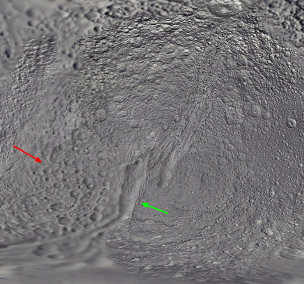
Note the improved Odysseus crater region and the vastly
smoothed transitions between the various texture patches.
The slightly yellowish coloration is computer-mapped as
usual from a /natural color/ image of Tethys.
Here are 2 views from the 4k textures from Celestia:
Bye Fridger
given that the Cyclops imaging team has released hires
maps of various Saturnian moons in December 2005, I
spent quite some time today preparing a new 4k Tethys
texture from these maps, merging in, however, the
relevant textures from the Voyager missions! They fit
very accurately and fill complementary regions in the
cylindrical Tethys map! Notably, the Voryager input
improves the region around the huge crater Odysseus
considerably, as well as the northern part of the texture.
Here are some images to provide a flavor of where I stand:
Here is a 1k texture (scaled down from the 4k size) that
you may download and try out:
Note the improved Odysseus crater region and the vastly
smoothed transitions between the various texture patches.
The slightly yellowish coloration is computer-mapped as
usual from a /natural color/ image of Tethys.
Here are 2 views from the 4k textures from Celestia:
Bye Fridger
Last edited by t00fri on 22.01.2006, 00:33, edited 1 time in total.
-
- Developer
- Posts: 3776
- Joined: 04.02.2005
- With us: 19 years 9 months
Fridger, before all, Tx as always; now I have two questions about this map;
the big problem is the use of 2 maps with different lightning; some craters have now their shadow on the west side, others almost south...
So question: there is not a way to create a bump map to avoid this? the good point with this is (also) to not lose for example this kind of canyon in the middle of the map, visible in the old map but not anymore in the new... (much more craters are almost invisible in the new map)
now just a question concerning the bigger crater on the east side almost at the equator; if you compare the old/new map, in the new one this crater is very oblate, and for a crater near the equator I find it strange... There is not a problem here?
Re: Thethys 4k , download the reduced 1k version for testing
Very nice work,Fridger.
-
Topic authort00fri
- Developer
- Posts: 8772
- Joined: 29.03.2002
- Age: 22
- With us: 22 years 7 months
- Location: Hamburg, Germany
ElChristou wrote:Fridger, before all, Tx as always; now I have two questions about this map;
the big problem is the use of 2 maps with different lightning; some craters have now their shadow on the west side, others almost south...
So question: there is not a way to create a bump map to avoid this? the good point with this is (also) to not lose for example this kind of canyon in the middle of the map, visible in the old map but not anymore in the new... (much more craters are almost invisible in the new map)
now just a question concerning the bigger crater on the east side almost at the equator; if you compare the old/new map, in the new one this crater is very oblate, and for a crater near the equator I find it strange... There is not a problem here?
(1) In such composite maps (mosaics) from many photographs taken at different positions of the sun this problem is rather unavoidable, I am afraid. In the ideal case one would would want a /flat (i.e. unshaded)/ base texture together with a bump(normal) map texture. Unfortunately we have neither!
In recent discussions in the developer list, we have agreed to eliminate any artificial bumpmaps from the distribution (so mercurybump, iapetusbump are gone and moonbump has been replaced by my /true/ elevation data). Synthesizing bumpmaps for high crater density is VERY difficult or even hopeless. As I discussed there, so-called "bumpmap generators" only work for bigger structures like "teapots (NVIDIA example)", ornaments etc, since texel /gradients/ have to be computed. Using the base texture as a fake elevation map is really a bad approximation in MANY cases.
But of course, I checked the display with my Tethys texture: in practice the problem is not too bad, really.
(2)As to the oval shape of that equatorial crater, I did not touch the Dec 2005 Cyclops map in this region at all. You see the same shape in the original map.
http://ciclops.org/view.php?id=1742
You also see its oval shape on Steve Albers' map who reprojected the data himself.
http://laps.fsl.noaa.gov/albers/sos/sos.html
But looking much more closely to the graphical quality of the Cyclops maps now during my work, I have become less enthusiastic about them...There is for example the beautiful, large and very detailed (northern) crater Telemachus on Tethys, whom I had to even replace since the Cyclops people almost destroyed it (by huge over contrast) during their work. Just compare yourself...
Bye Fridger
-
- Developer
- Posts: 3776
- Joined: 04.02.2005
- With us: 19 years 9 months
-
Topic authort00fri
- Developer
- Posts: 8772
- Joined: 29.03.2002
- Age: 22
- With us: 22 years 7 months
- Location: Hamburg, Germany
ElChristou wrote:Fridger, please, can you point me to a 4k map from Voyager mission?
Sorry, 4k doesn't exist. The best "complementary" view from voyager with the big Odysseus crater and the "canyon" near the pole is in medres/tethys.jpg. I had to blow it up to 4k.
Apart from that there is only a 2k Voyager texture from jens/Jim in ML.
I could actually not locate the scientific origin of our medres/tethys.jpg texture. The "standard people" (BJ, Stokes...) did not have it on their sites.
Bye Fridger
-
- Developer
- Posts: 3776
- Joined: 04.02.2005
- With us: 19 years 9 months
-
Topic authort00fri
- Developer
- Posts: 8772
- Joined: 29.03.2002
- Age: 22
- With us: 22 years 7 months
- Location: Hamburg, Germany
ElChristou wrote:t00fri wrote:...Apart from that there is only a 2k Voyager texture from jens/Jim in ML.
pfff... the Jens map on ML is Jpeg or dds, but... this is not a problem, the link is broken!!!
That's the least problem, I have access to Jens' home dir:
(and you know that I tend to avoid ML if possible )
http://www.celestiaproject.net/~t00fri/images/ ... pg_dds.zip
But that's probably NOT the view you want, since the Cassini data are WAY better.
Bye Fridger
-
- Developer
- Posts: 3776
- Joined: 04.02.2005
- With us: 19 years 9 months
t00fri wrote:That's the least problem, I have access to Jens' home dir:
(and you know that I tend to avoid ML if possible )
http://www.celestiaproject.net/~t00fri/images/ ... pg_dds.zip
Hey, Tx. I want to do some tweaking just to see....
t00fri wrote:But that's probably NOT the view you want, since the Cassini data are WAY better.
Bye Fridger
Sure, but I suppose that those Cassini datas are Raws, and as I still cannot use mmps...
-
Topic authort00fri
- Developer
- Posts: 8772
- Joined: 29.03.2002
- Age: 22
- With us: 22 years 7 months
- Location: Hamburg, Germany
ElChristou wrote:t00fri wrote:That's the least problem, I have access to Jens' home dir:
(and you know that I tend to avoid ML if possible )
http://www.celestiaproject.net/~t00fri/images/ ... pg_dds.zip
Hey, Tx. I want to do some tweaking just to see....t00fri wrote:But that's probably NOT the view you want, since the Cassini data are WAY better.
Bye Fridger
Sure, but I suppose that those Cassini datas are Raws, and as I still cannot use mmps...
No, the Cassini data are cylindical maps! Here is the reference.
http://saturn.jpl.nasa.gov/multimedia/i ... ageID=1929
But the Odysseus crater (the big one on the left) is much more detailed in the Voyager data (medres/tethys.jpg) ...
Bye Fridger
What about Steve Albers??textures.Aren??t they true 4k textures?
t00fri wrote:ElChristou wrote:Fridger, please, can you point me to a 4k map from Voyager mission?
Sorry, 4k doesn't exist. The best "complementary" view from voyager with the big Odysseus crater and the "canyon" near the pole is in medres/tethys.jpg. I had to blow it up to 4k.
Apart from that there is only a 2k Voyager texture from jens/Jim in ML.
I could actually not locate the scientific origin of our medres/tethys.jpg texture. The "standard people" (BJ, Stokes...) did not have it on their sites.
Bye Fridger
-
Topic authort00fri
- Developer
- Posts: 8772
- Joined: 29.03.2002
- Age: 22
- With us: 22 years 7 months
- Location: Hamburg, Germany
danielj wrote:What about Steve Albers??textures.Aren??t they true 4k textures?t00fri wrote:ElChristou wrote:Fridger, please, can you point me to a 4k map from Voyager mission?
Sorry, 4k doesn't exist. The best "complementary" view from voyager with the big Odysseus crater and the "canyon" near the pole is in medres/tethys.jpg. I had to blow it up to 4k.
Apart from that there is only a 2k Voyager texture from jens/Jim in ML.
I could actually not locate the scientific origin of our medres/tethys.jpg texture. The "standard people" (BJ, Stokes...) did not have it on their sites.
Bye Fridger
Daniel,
the question was about 4k /Voyager/ textures. Steve uses the same raw image sources I use, too.
-
- Posts: 64
- Joined: 06.11.2003
- With us: 21 years
- Location: Notts, UK
t00fri wrote:But the Odysseus crater (the big one on the left) is much more detailed in the Voyager data (medres/tethys.jpg) ...
Out of interest it was only a few days after the new Cassini cylindrical maps were released that better raw images of the Odysseus crater region were available.
http://saturn1.jpl.nasa.gov/multimedia/ ... geID=59018
Index page for Tethys
Regards, Losty
-
Topic authort00fri
- Developer
- Posts: 8772
- Joined: 29.03.2002
- Age: 22
- With us: 22 years 7 months
- Location: Hamburg, Germany
lostfisherman wrote:t00fri wrote:But the Odysseus crater (the big one on the left) is much more detailed in the Voyager data (medres/tethys.jpg) ...
Out of interest it was only a few days after the new Cassini cylindrical maps were released that better raw images of the Odysseus crater region were available.
http://saturn1.jpl.nasa.gov/multimedia/ ... geID=59018
Index page for Tethys
Indeed, I found those about half an hour ago as well. It might well be worth reprojecting them into a simple cylindrical map...I'll see what I can do...
Bye Fridger
-
- Developer
- Posts: 3776
- Joined: 04.02.2005
- With us: 19 years 9 months
If the coloration were strictly due to shadows, then maybe.
Don't forget that real surfaces also have different shades of coloration because of different mineral content. The light and dark areas are not all due to shadows.
One method is described at http://phobos.physics.uiowa.edu/curriculum/lunar.html
Don't forget that real surfaces also have different shades of coloration because of different mineral content. The light and dark areas are not all due to shadows.
One method is described at http://phobos.physics.uiowa.edu/curriculum/lunar.html
Selden
-
- Developer
- Posts: 3776
- Joined: 04.02.2005
- With us: 19 years 9 months
selden wrote:Don't forget that real surfaces also have different shades of coloration because of different mineral content. The light and dark areas are not all due to shadows.
you're right...
...but even, such a tool would be usefull for lots of asteroids and bodies with a quite regular composition...
-
- Developer
- Posts: 3776
- Joined: 04.02.2005
- With us: 19 years 9 months
Fridger,
What about merging very smoothly the previous map in the zone of the red arrow and also keeping part of the shadow of the "canyon"; I know we lose the integrity of the scientific data, but view the differences between all those "official" maps, is this really a problem? personally I tend to search for a map with the maximum of informations about the geography... what do you think?
-
Topic authort00fri
- Developer
- Posts: 8772
- Joined: 29.03.2002
- Age: 22
- With us: 22 years 7 months
- Location: Hamburg, Germany
I'll have a look tonight.
Soft merging of the two texture layers in this region may also have the benefit of diminishing the "over-contrast" mismatch of the old Voyager data with the new Cassini data. As you surely noticed in the old data, craters looked MUCH deeper etc. than in the new higher resolution data.
The region you indicated is about the only region in the map where a soft merging with a certain transparency ratio might be a profitable option.
Yet on the scale of the higher resolution Cassini data, the canyon you left towards the south appears WAY too deep. I actually had tried to match its depth appearance to the hires data.
Bye Fridger