Hello all,
Astronauta, what you are doing is exactly what I am trying to achieve since years ... Congrats for the beautiful results !

As an astronomer, I study ancient Egyptian astronomy. I more particularly focus on the determination of the days of rising and setting of stars visible with the naked eye in the darkness and twilight. For the needs of my Ph.D, I have developed little scripts which mix celestial mechanics algorithms and visibility criteria and lead to the determination, with good accuracy, of the time of rising and setting of stars above the horizon - above a flat horizon only. I would now like to go further and take into account the local relief.
To achieve this goal, I have considered using several softwares like VTProject, Cesium, OpenLayers with Cesium, NASA WebWorldWind, etc. But none of them really answered my needs ... until I re-discovered Celestia. After one month testing its functionalities and studying its functioning, I am convinced that this software could really lead to determine, theoretically and visually, the height of appearance/disappearance of any object above/below the local horizon, hence the instants at which these phenomena occur in darkness as well as in the twilight sky.
i am therefore really interested in what you achieved, Astronauta. Reading the Celestia documentation and the different users contributions - that of GlobeMaker especially (
viewtopic.php?f=6&t=8917), I understand that the first step is to conceive a 3D model of the Earth terrain on the basis of a DEM and with the help of a software like Blender-GIS or Anim8or. Is that right ? Is this your approach ? If so, would it be possible for you to detail it a bit so that I can conceive my own 3D model ? Thanks in advance.
Of course, let me know if I can contribute to your efforts with my few skills.


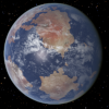
 Viewed 9854 times")
 Viewed 9854 times")
 Viewed 9854 times")
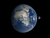
 Viewed 9871 times")
 Viewed 9871 times")


 Viewed 9693 times")