Mars Center of Gravity not at Center of Shape

General physics and astronomy discussions not directly related to Celestia
Topic author
GlobeMaker
Posts: 216
Joined: 30.10.2005
With us: 18 years 7 months

Mars Center of Gravity not at Center of Shape

Post #1by GlobeMaker » 02.11.2005, 16:25

I designed a 3D model of Mars with mountains exaggerated 250 times taller.
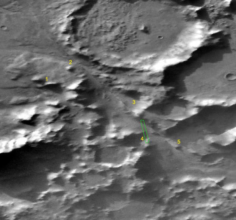
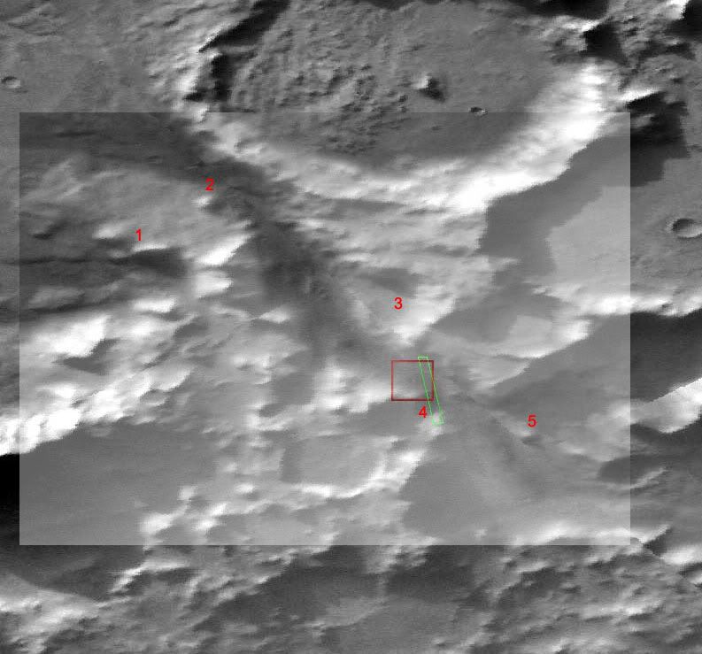
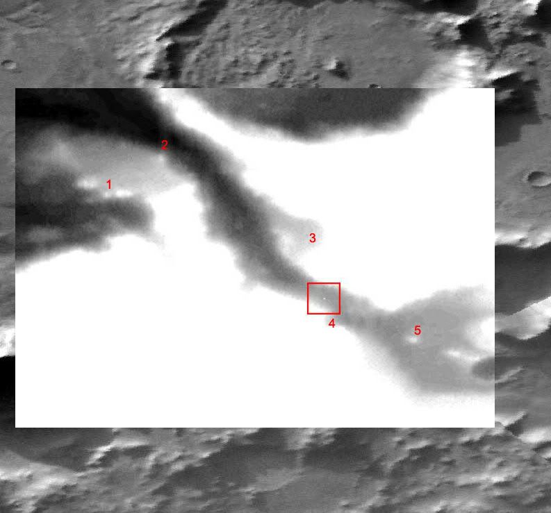
The tall volcanoes do not point away from the center of the planet, they point away from the center of gravity :

Image

The volcanos do not point away from the geometric center of the planet. Look at Olympus Mons. Draw a straight like through Olympus Mons and the line is off-center compared to the middle of the image. Speculation about the cause of the surprising direction in which Olympus Mons grew has begun.

Also Ascraeus Mons has a similar offset in its direction, compared to the center of Mars. Maybe there is a dense iron core in Mars that is not centered. A collision by an iron asteroid could place the iron in an offset position. The image has blue lines drawn through the volcanos to show the center of gravity. A green dot was added to show the center of the shape of Mars. Notice that the center of gravity is not in the same place as the center of the shape.

Hellas Planitia appears as the flat side of Mars, opposite Olympus Mons. In the picture, three green lines have been draw parallel to Hellas Planitia. A yellow line was drawn to be perpendicular to Hellas Planitia. That yellow line goes toward the center of gravity. One may speculate that a large asteroid hit Hellas Planitia while traveling in the direction of the yellow line. That asteroid may have stopped at the center of gravity.

see http://www.reliefglobe.com/mars.html
Your wish is my command line.

tony873004
Posts: 132
Joined: 07.12.2003
With us: 20 years 6 months
Location: San Francisco http://www.gravitysimulator.com

Post #2by tony873004 » 05.11.2005, 10:49

That's very cool!

Why should they point to the geographic center? Local "down" is going to be towards center of mass.

It's amazing what you can expose by severely exaggerating a system.

cpotting
Posts: 164
Joined: 18.03.2004
Age: 62
With us: 20 years 3 months
Location: Victoria, BC Canada

Post #3by cpotting » 05.11.2005, 14:33

Besides, only a symmetrical object could be expected to always point "down". If the cone of a volcano is off-centre because of uneven distribution of the ejecta (I think that's the right term), or because part of it was blown off, or any of a number of different reasons, then a cross-section of the object would look like an off-skew cone

.................x......
.............xxxx.....
.........xxxxxxx....
.......xxxxxxxxx...
.....xxxxxxxxxxx..
....xxxxxxxxxxxx..
..xxxxxxxxxxxxxx.
xxxxxxxxxxxxxxxx

Now exagerate the height 250 times and draw a line through what appears to be the centre and it will most definitely NOT point down.
Clive Pottinger
Victoria, BC Canada

Topic author
GlobeMaker
Posts: 216
Joined: 30.10.2005
With us: 18 years 7 months

Post #4by GlobeMaker » 05.11.2005, 19:33

Here is my response to cpotting who wrote :
"Besides, only a symmetrical object could be expected to always point "down". If the cone of a volcano is off-centre because of uneven distribution of the ejecta (I think that's the right term), or because part of it was blown off, or any of a number of different reasons, then a cross-section of the object would look like an off-skew cone "

Yes. However, every volcano points away from the same non-central place. How could every volcano have uneven distribution that consistently points to the same non-central zone? I would expect that volcanos with sides blown away would have a random distribution of uneven ejecta. The image that I have posted does not show a random set of directions for volcanic cones, but a systematic bias toward what I call "the center of gravity".

The image is a discovery image showing a non-random offset of volcanic cone growth. I will inform NASA next Wednesday of this discovery image when they call me for a scheduled interview. The NASA publication "Spinoff" wants to publish an article on the Mars Globe 20x product from my company. After I tell them about the center of gravity being displaced to a point under Ellysium Mons, I hope that the interviewer will inform me about whether their scientists already know of the offset, of whether this is a new discovery.

The image of the Mars 250x relief globe is based on MGS MOLA (Mars Global Surveyor , Mars Orbiter Laser Altimeter). It used 8 data points per degree of latitude and longitude.

Thank you for your interest in the Mars 250x "discovery image".

( I also discovered a "tower" on Mars that is 1500 feet tall and 1500 feet wide). It is in the bottom of a river bed.

Argyre Planitia and The Tower

The Happy Face Crater is North of the Tower. It is East of Argyre Planitia. This crater is known as Galle Crater. It is about 215 kilometers (134 miles) across. The tower has no name yet, but it is about 1500 feet tall. That is
like the tallest building in an Earth city. I found it while searching for rivers leading into the huge depression called Argyre Planitia. I can post an image of it if there is any interest.
Your wish is my command line.

Malenfant
Posts: 1412
Joined: 24.08.2005
With us: 18 years 10 months

Post #5by Malenfant » 05.11.2005, 19:59

GlobeMaker wrote:The image is a discovery image showing a non-random offset of volcanic cone growth. I will inform NASA next Wednesday of this discovery image when they call me for a scheduled interview. The NASA publication "Spinoff" wants to publish an article on the Mars Globe 20x product from my company. After I tell them about the center of gravity being displaced to a point under Ellysium Mons, I hope that the interviewer will inform me about whether their scientists already know of the offset, of whether this is a new discovery.

I'm not entirely sure it is a discovery. It's already known that the Tharsis Bulge makes Mars asymmetrical in terms of mass distribution, this may just be a side-effect of that. See here for example. Dammit, I've got the name of one of the people who wrote a paper on this on the tip of my tongue... she's hispanic, been to Mars conferences, I can see her face in my mind but I can't remember her name, argh!

EDIT: Maria Zuber! That was her name! :)

( I also discovered a "tower" on Mars that is 1500 feet tall and 1500 feet wide). It is in the bottom of a river bed.


This also sounds a bit familiar. I wouldn't mind seeing the image of it if you don't mind.
Last edited by Malenfant on 06.11.2005, 23:34, edited 1 time in total.

cpotting
Posts: 164
Joined: 18.03.2004
Age: 62
With us: 20 years 3 months
Location: Victoria, BC Canada

Post #6by cpotting » 06.11.2005, 05:05

GlobeMaker wrote:Yes. However, every volcano points away from the same non-central place. How could every volcano have uneven distribution that consistently points to the same non-central zone? I would expect that volcanos with sides blown away would have a random distribution of uneven ejecta. The image that I have posted does not show a random set of directions for volcanic cones, but a systematic bias toward what I call "the center of gravity".

Ahh, I hadn't caught the full implication of what you were showing in your first post.

I don't want to sound negative, and I'm by no means an expert, but I don't see it being likely that this is a new discovered effect. If I read your illustration correctly, then even though the terrain height is exagerated, the displacement of the "centre of gravity" from the "centre of Mars" is not. In that case, the shift shown is over a significant fraction of the radius of the planet.

It seems that telescopic oberservation and most definitely data from probes would have returned data on such a great difference is gravitational centres.

I'm not saying your wrong - there is definitely something there - those lines do meet off centre. I just can't see such a large displacement of the centre of gravity being unnoticed for so long.

Or am I interpreting your diagram incorrectly?
Clive Pottinger
Victoria, BC Canada

Topic author
GlobeMaker
Posts: 216
Joined: 30.10.2005
With us: 18 years 7 months

Post #7by GlobeMaker » 06.11.2005, 16:43

In response to the question : "the shift shown is over a significant fraction of the radius of the planet. Or am I interpreting your diagram incorrectly?"

No, are interpretting correctly : The "possible center of gravity" is shifted a significant fraction of Mars' radius. Even though heights are exaggerated 250 times, the directions that the volcanoes point in is not exaggerated. Any satellites orbiting Mars would orbit the center of gravity, so I expect this shift is already known, or this shift does not exist and is only due to errors in my work.

Concerning the "Tower" you can see pictures with heights exaggerated 7x at http://www.reliefglobe.com/mars_price15.html
Here is one picture of The Tower 190 km South of Galle Crater :

Image
Your wish is my command line.

Malenfant
Posts: 1412
Joined: 24.08.2005
With us: 18 years 10 months

Post #8by Malenfant » 06.11.2005, 17:23

Hm. Something as small as that could be anything from a real tower/mesa to a data glitch. It looks like it could just be one pixel in a MOLA map that's got an errant brightness, that could be anything.

Personally, I think it's a shame you exaggerate the relief so much - I think the 250x ones are horribly ugly (sorry!). the images on that page look much better IMO and they're at 7x exaggeration. What would that last image look like at 1 or 2x exaggeration?

Do you use MOLA maps (the ones that show height as greyscale) to generate your models? Which is the original file that this "tower" is shown on?

Topic author
GlobeMaker
Posts: 216
Joined: 30.10.2005
With us: 18 years 7 months

Post #9by GlobeMaker » 06.11.2005, 18:12

Malenfant asked : "Do you use MOLA maps (the ones that show height as greyscale) to generate your models? Which is the original file that this "tower" is shown on?"

I am not using gray scale pictures, I am using MOLA topographical files from this website :

http://pds-geosciences.wustl.edu/geodat ... 0x/meg128/

I downloaded all those topo files, including the topo file that has Galle Crater in it and my program automatically loaded that file in response to me providing a latitude and longitude ( Longitude 326 East, Latitude 54 South ). The exact filename is selected by my program, but after some human review, the filename is : megt44s270hb.img

This covers the region
MAXIMUM_LATITUDE = -44.0 <DEGREE>
MINIMUM_LATITUDE = -88.0 <DEGREE>
WESTERNMOST_LONGITUDE = 270.0 <DEGREE>
EASTERNMOST_LONGITUDE = 360.0 <DEGREE>

Yes, it is one data point that makes it look like a tower at 7x exaggeration. Yes, it may be one glitch in the database. Yes, Mars is ugly when exaggerated 250x. But I do not care about ugliness when I am on my explorations of that alien world. What other non-NASA people are searching river beds on Mars to discover whatever presents itself? Nobody else has the GlobeMaker Software, and I feel like a remote Henry Hudson exploring a new world. If I report that "dragons be there" when I find strange sights, then please, do not take my word for it, explore the river valleys near Galle Crater yourself.

The last picture on my Tower webpage, if shown with 1x (no exaggeration) would look like a pyramid 1500 feet wide and 1500 feet tall. Someday, that river valley could be photographed in detail to determine if this possible tower is a glitch, or if it is a big rock that fell off the canyon wall. But in all my searching of Mars' features, this is the only glitch of this type that I have seen. And I have explored 3D Mars models for many hours in dozens of various locations spanning the globe. You can visit my office in California to join me using the GlobeMaker Software to explore Martian landforms. Or I can produce files for you to explore yourself. In fact, I can mail you the 3D data file in .stl , .3ds or .cmod format of the Galle Crater region for you to download and explore. These are Simulated Mars Globe sections using 128 data points per degree of latitude and longitude. Each section is 11 degrees by 22.5 degrees, which is about 400 miles by 800 miles. Each .stl file is 400 megabytes. If all of Mars were modeled this way, the total file size would be 100 gigabytes.
Your wish is my command line.

Malenfant
Posts: 1412
Joined: 24.08.2005
With us: 18 years 10 months

Post #10by Malenfant » 06.11.2005, 18:57

OK, OK, no need to get so defensive! Sheesh.

Thing is, your "tower" is only a tower if looked at with massive vertical exaggeration. As you say, at 1x exag it would be a 1500x1500 ft 'pyramid' - and in reality it wouldn't even be a pyramid because that shape is just an artifact of the grid size used. It might just be an ordinary small hill that is a few hundred metres high - nothing special at all.

One thing's for sure, you can't really say much by looking at the topography alone. Do you know the exact lat/lon of the "tower" itself? I'm trying to find some MOC images of that specific area but it's too small for me to be able to to get a bearing on where I have to look.

Topic author
GlobeMaker
Posts: 216
Joined: 30.10.2005
With us: 18 years 7 months

Post #11by GlobeMaker » 06.11.2005, 20:00

The possible Tower is located at a longitude of 327.3047 degrees East. The latitude is 54.8142 degrees South. Here is a locator image to confirm the reasonableness of these coordinates :

Image

The 5 black lines converge on the possible Tower location.

That picture is on my website at : http://www.reliefglobe.com/mars_price15.html
Your wish is my command line.

Malenfant
Posts: 1412
Joined: 24.08.2005
With us: 18 years 10 months

Post #12by Malenfant » 06.11.2005, 20:10

I managed to get megt44s270hb.img open with NASAview and found Galle on it. Here's a link to the 'image' version of topography at that resolution (white is high, black is low).

I can't unambiguously identify anything that could be your tower on that. There's a couple of bright spots in the lower left corner, north of the big ridge there - is one of those what you're looking at? They can't be, because these maps are 128 pxls/degree, which is 0.463 km/pxl. So your tower has to be one pixel wide here, which is too small to identify anything (in planetary image interpretation a feature needs to be at least two pixels wide to be identifiable).

EDIT: Oh wait. Here's a very hugely histogram-stretched version of that area. (you'll have to download the image and zoom in to see it)

Image

There's a single pixel in the valley there that's brighter than the rest. In the unstretched image, the surrounding pixels have a DN of about 97, but that one is 104. (DN is the "Data Number" from 0 to 255 used to measure the greyscale value for that pixel).

So there is something in the data, but whether that is something real or anything interesting is another matter entirely. At best it's an isolated hill or mesa.

Malenfant
Posts: 1412
Joined: 24.08.2005
With us: 18 years 10 months

Post #13by Malenfant » 06.11.2005, 20:25

BTW, the closest MOC images I could find were:
http://ida.wr.usgs.gov/html/e13002/e1300284.html
http://ida.wr.usgs.gov/html/m08055/m0805509.html

The last one is VERY close, but I don't think it covers the tower itself.

Topic author
GlobeMaker
Posts: 216
Joined: 30.10.2005
With us: 18 years 7 months

Post #14by GlobeMaker » 06.11.2005, 22:00

Thanks for looking up those pictures of that river valley. It appears that there is a hill in the river valley where the simulated tower is. The pictures show nothing special about the hill. It is in the middle of a river valley, but there are other hills in similar positions.

My conclusion is that it is not a glitch in the data, it is a hill. It caught my attention more than other hills. That may be due to its size being right for one point being tall and all surrounding points being low.

Here is a contrast enhanced image to locate the tower. A black square is drawn around the dim white spot.

Image
Your wish is my command line.

Malenfant
Posts: 1412
Joined: 24.08.2005
With us: 18 years 10 months

Post #15by Malenfant » 06.11.2005, 22:11

GlobeMaker wrote:Here is a contrast enhanced image to locate the tower. A black square is drawn around the dim white spot.

Image


Interesting. That wasn't what I was looking at. :) The pixel I found is off to the east of that, in the valley.

I blew up the stretched image and put a box around what I found.

Image

The region in your black box is too broad to be the tower - it's several pixels wide (i'm pretty sure it's one of the bumps near the valley wall that you can see behind the tower in your perspective view). The dot I found is just a single pixel that is slightly higher in DN than the surrounding area which seems more like your tower - looks like it's in the right place too, further from the walls.

speedfreek
Posts: 13
Joined: 19.08.2005
With us: 18 years 10 months
Location: London UK

Post #16by speedfreek » 07.11.2005, 01:02

Very interesting! I took the Viking context image from http://ida.wr.usgs.gov/html/m08055/m0805509.html and superimposed the above image on it.

Notice the 5 reference points I have marked
Image

Now I marked the same points on the version of megt44s270hb.img posted above, and superimposed them.. they were already at exactly the correct scale. :?
Image

If you refer between the picture below and the top one, where the lone pixel is, there is nothing there but what looks like a dark gentle slope with what seems to be a slightly darker area right where the data point is.
Image

So seem to be 3 possibilites here.
1. The data point that generated the "tower" was a data error, as there is nothing significant on the Viking image.
2. Something big has appeared on the martian surface after Viking took that picture.
3. There is something there in the Viking picture that is very big, dark and non-reflective.

:?:

Topic author
GlobeMaker
Posts: 216
Joined: 30.10.2005
With us: 18 years 7 months

Post #17by GlobeMaker » 07.11.2005, 01:48

The Tower : A SpeedFreak posted some combined images. In the first image, a black dot appears at the position of the tower. The direction of the shadows is such that Viking could only see the shadow and not the lit side. In the second image, the white dot is touching the black dot to its left. The white dot was contrast enhanced, while the Viking's black dot was not enhanced.

The Viking image was taken from a tilted view so craters are all ovals. The tower is so steep that the lit side is completely tilted away from the Viking camera. I disagree with the 3 possibilities :

1 Viking recorded a black dot. The sun has backlit the tower.
2 The dot is black for Viking, white for topo data. It was there in both pictures.
3 There is something there in the Viking picture that is small, steep, and tilted away from the camera angle.

Center of Gravity of Mars : Imagine the following : an asteroid hit Hellas Planitia when Mars was much hotter and had a molten interior. Over several years, the asteroid penetrated to the "old center of gravity under Ellysium Mons". It caused volcanoes to erupt that pointed away from the center of gravity. The surface froze solid with volcanoes pointing away from the "old center of gravity under Ellysium Mons". The core remained molten longer than the surface. Over 100 mega-years the heavy iron asteroid moved to the new center of gravity that is now present. Today, satellites orbit the geometric center and that is where the present day center of gravity is. The volcanoes are still frozen in positions that point to the "old center of gravity under Ellysium Mons".

This explains why volcanoes point to the "old center of gravity under Ellysium Mons" while modern satellites do not orbit that point. They orbit a new center of gravity near the geometric center.
Your wish is my command line.

speedfreek
Posts: 13
Joined: 19.08.2005
With us: 18 years 10 months
Location: London UK

Post #18by speedfreek » 07.11.2005, 18:11

Well, Viking did not record a BLACK dot at that position, all I can see is a slightly darker area. To me, it looks like a slight depression at best. I believe that the most plausible explanation is a rogue data point. I put in the other 2 possible explanations for completeness, but I wasn't really serious about them. :roll:

wcomer
Posts: 179
Joined: 19.06.2003
With us: 21 years
Location: New York City

Post #19by wcomer » 08.11.2005, 01:17

Mars is a spheroid. So volcanos do not point to the center of mass. And there is nothing mysterious about this. Volcanos point to the surface normal. The sample of volcanos happens to be conveniently situated within the same hemisphere so they appear to focus in the same region. Additionally I supect that either the algorithm you used for exagerating the heights is distorting the spheroid and thus bringing the focus of the volcanos closer to the surface, or the algorithm you are using to project off the surface normal to the spheroid is horribly mangled. I can't decide which from the image provided.

Btw, I think your globes look very nice.

Topic author
GlobeMaker
Posts: 216
Joined: 30.10.2005
With us: 18 years 7 months

Post #20by GlobeMaker » 08.11.2005, 01:48

Wcomer said : "volcanos do not point to the center of mass...Volcanos point to the surface normal".

Where did you get that idea? It is not credible. Please cite a reference for that idea. Gravity never sleeps. Surface normals are an artifical concept that depends on scale. Each grain of sand has many surface normals. Gravity has a local direction vector that is well defined. Surface normals are vectors that can be calculated in many directions, depending on the scale of local interest. If you can cite a credible reference for "volcanos do not point to the center of mass...Volcanos point to the surface normal" then I will revise my speculations.

Please conside photos of Mount Shasta in California. On the West Flank of the 14000 foot volcano is a smaller volcano called Shastina. It is oriented to point to the Earth's center of gravity. Shastina does not point away from the surface normal on the tilted flank of Mt. Shasta. Gravity causes scree to fall away in a direction that builds up a cone that points away from the center of gravity. The scree does not build up due to normals to the tilted flank. If it did, Shastina would grow at a 20 degree angle relative to the gravity vector. As it grew, it would defy gravity, under the stronger influence of "your normal forces theory". If you are right, then I will go read some books on the amazing "normal physics" that you will cite.

Wcomer said "Mars is a spheroid....the algorithm you used for exagerating the heights is distorting the spheroid". A spheroid is a simplified description of this irregular shape. The irregular shape is distorted due to exaggeration. The distortion is mathematically understood and it is not flawed. Lowlands get lower. Highlands get higher. These changes are done with precise mathematical transformations that are clear to me.

Wcomer said "or the algorithm you are using to project off the surface normal to the spheroid is horribly mangled.". The algorithm has mathematical perfection.

You can draw more lines through all peaks in the image and you will find that they point to the same region under Ellysium Mons.

Thank you for your interest in this speculation about the old center of gravity of Mars that existed while the volcanoes were active. After they became extinct, the center of gravity shifted to its present location, I speculate.
Your wish is my command line.


Return to “Physics and Astronomy”