
danielj,
I am afraid its just not that simple for a number of reasons. First, the maximum average snow coverage seen in the new textures is very differnt the data for the las ice age. Ocean levels were lower witch means I would have to do a about 24 more times of the coastal data than the first time. Also the detail you see in the winter texture simply will not there because the ice was about 2 killometers in its thikest areas. Needless to say there simply wouldn't be any arborial forest to see in the ice covered areas. In all it would probably take 6 months at least to try and put it all together to make it look good. And then it still wouldn't be acurate because all I have is satalite information of how the Earth looks today. The glacial erotion that has molded our mountains and valleys and they would have to be modified and guessed at. I was able to get away with the lack of knowledge with the old texture because of its size. But at 16k the errors would look very obvious. That simply wouldn't be accepted by most Celestia and other users of my textures if I tried it. Not to toot my own horn but a few of my textures have been been used now by profesionals in both the private and state govermental arenas. So for me to stay accurate is priority one. Or as acurate as posible. I actualy had to turn down the use of my Earth Mark 1 texture that I made for the NASA Orpheus-Earth collision educational project. It was going to be used in a documentary for the Discovery chanel. I simply could not reach their deadline for the texture without having my own internet conection. This hurt me more than any of you will ever know. I would have had my in the credits and who knows were it could have taken me. Oh well such is life. Maybe the next time.
Don. Edwards
Sneak Peek! New Pictures Added!!!!
-
Topic authorDon. Edwards
- Posts: 1510
- Joined: 07.09.2002
- Age: 59
- With us: 22 years 6 months
- Location: Albany, Oregon
-
granthutchison
- Developer
- Posts: 1863
- Joined: 21.11.2002
- With us: 22 years 4 months
Beautiful as ever, Don.
In the full northern winter texture, you might like to ice in a goodly proportion of Lake Superior ... when I worked in Thunder Bay, I can remember standing on top of a hill in March, watching the ice-breaker carve a channel into port; otherwise there was ice as far as I could see.
To give you an idea of the extent and distribution, here's a set of infrared images at various wavelengths, showing ice-cover in February on Lake Superior:
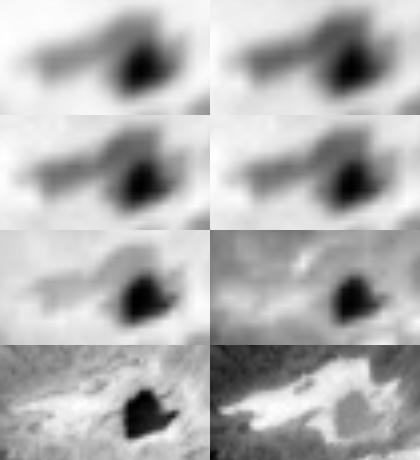
The darker area at lower right in each image is open water, but the rest of the lake is covered in ice.
Grant
In the full northern winter texture, you might like to ice in a goodly proportion of Lake Superior ... when I worked in Thunder Bay, I can remember standing on top of a hill in March, watching the ice-breaker carve a channel into port; otherwise there was ice as far as I could see.
To give you an idea of the extent and distribution, here's a set of infrared images at various wavelengths, showing ice-cover in February on Lake Superior:
The darker area at lower right in each image is open water, but the rest of the lake is covered in ice.
Grant
-
granthutchison
- Developer
- Posts: 1863
- Joined: 21.11.2002
- With us: 22 years 4 months
Oh, here's a better link for you, giving ice cover for the whole of the Lakes, both in 2003 (which was a bad winter like the 1996 images of Superior above), and also the average ice conditions - but there are big chunks of the Lakes socked in with ice in both cases.
http://www.glerl.noaa.gov/pubs/brochures/ice/icechart2003.html
Grant
http://www.glerl.noaa.gov/pubs/brochures/ice/icechart2003.html
Grant
-
Topic authorDon. Edwards
- Posts: 1510
- Joined: 07.09.2002
- Age: 59
- With us: 22 years 6 months
- Location: Albany, Oregon
Grant,
Thanks for the info. The animated gif didn't show this info. I will add this info at once. It shouldn't delay the release by much. I know I said I might have things ready today but I am going to need a few more days. I am still working on the new cloud textures. I have the new northern summer cloudmap and northern winter cloudmaps finished for the most part. The main ones are at 8k but I will have 4k available as well for those that might want to animate them.
So here are a few shots showing the winter and summer textures with there corisponding coludmaps.
Northern Winter first.


Here is the new Northern Summer


And finaly a few close-ups showing the new detail in the cloudmaps.


If you look close will notice that the Huricanes, Typhoons, and Cyclones have been made smaller by 25%. When I made the last Norhtern Summer cloudmap I forgot to take into consideration that once the cloudmap would get placed over a sphere that the storms would get stretched some. So they tended to look a little to big to some users including me. Someone also mentioned that I had to many of tham at one time. I have checked on this and from some animated weather loops I have seen and they show that there can be several of these storms going on at the same time. The Eastern Pacific Ocean creates on average 3 times as many Huricanes than form in the Atlantic and Caribean Sea. I did use some of the same storm image data but I have moved a few of them around and exchanged afew here and there. In the end I ended up with a much better cloudmap than the last one and the detail has inproved I feel by a factor of two. Of course you the users will be the ones to make the final choice.
As always, comments are welcome.
Don. Edwards
Thanks for the info. The animated gif didn't show this info. I will add this info at once. It shouldn't delay the release by much. I know I said I might have things ready today but I am going to need a few more days. I am still working on the new cloud textures. I have the new northern summer cloudmap and northern winter cloudmaps finished for the most part. The main ones are at 8k but I will have 4k available as well for those that might want to animate them.
So here are a few shots showing the winter and summer textures with there corisponding coludmaps.
Northern Winter first.
Here is the new Northern Summer
And finaly a few close-ups showing the new detail in the cloudmaps.
If you look close will notice that the Huricanes, Typhoons, and Cyclones have been made smaller by 25%. When I made the last Norhtern Summer cloudmap I forgot to take into consideration that once the cloudmap would get placed over a sphere that the storms would get stretched some. So they tended to look a little to big to some users including me. Someone also mentioned that I had to many of tham at one time. I have checked on this and from some animated weather loops I have seen and they show that there can be several of these storms going on at the same time. The Eastern Pacific Ocean creates on average 3 times as many Huricanes than form in the Atlantic and Caribean Sea. I did use some of the same storm image data but I have moved a few of them around and exchanged afew here and there. In the end I ended up with a much better cloudmap than the last one and the detail has inproved I feel by a factor of two. Of course you the users will be the ones to make the final choice.
As always, comments are welcome.
Don. Edwards
I am officially a retired member.
I might answer a PM or a post if its relevant to something.
Ah, never say never!!
Past texture releases, Hmm let me think about it
Thanks for your understanding.
I might answer a PM or a post if its relevant to something.
Ah, never say never!!
Past texture releases, Hmm let me think about it
Thanks for your understanding.
Hi Don,
I love these detailed cloud maps. It's so annoying when you move toward the earth and a few gray pixels take up the entire screen.
I only wonder if you should move some of the hurricane systems so they are not exactly in a line with each other. It may be realistic, but my attention is overly drawn toward this feature and it's hard to focus on the rest of the clouds with something so coincidental in there.
Just my thoughts.
Joe
-
Topic authorDon. Edwards
- Posts: 1510
- Joined: 07.09.2002
- Age: 59
- With us: 22 years 6 months
- Location: Albany, Oregon
alphap1us,
Unfortunatly the cloud textures you see are finished and locked in. Making these cloudmaps are very time consuming. You are corect that the there positions are for the most part acurate and is how they would look from space. The only areas were they move farther north are along the eastern seaboard of the USA and in the western pacific near Japan. There are still two more seasonal cloudmaps to go and you will see something different. But you have to remember that I only have the original cloudmap texture from BlueMarble to work with. I can only do so much with it.
Don. Edwards
I am officially a retired member.
I might answer a PM or a post if its relevant to something.
Ah, never say never!!
Past texture releases, Hmm let me think about it
Thanks for your understanding.
I might answer a PM or a post if its relevant to something.
Ah, never say never!!
Past texture releases, Hmm let me think about it
Thanks for your understanding.